OS1/35/87/5


| List of names as written | Various modes of spelling | Authorities for spelling | Situation | Description remarks |
|---|---|---|---|---|
| DUNMAN | Dunman Dunman Dunman Dunman Hill Dunman Dunman |
William Todd John Brown Statistical account of Wigtonshire page 207 Rl Engrs [Royal Engineers] Map 1819 Ainslie's Map 1782 Map of Scotland |
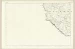
035 | [situation] Adjoining the Sea Coast & about ¾ mile west of Auchneight (farm house) A rocky hill on the farm of Slock it is of a small extent although the highest in the Parish, its Western side is very precipitous and the base is washed by the sea. On its summit is the trace of an old Pictish Fort. |
| DUNMAN WELL | Dunman Well Dunman Well |
William Todd John Brown |
035 | [situation] On the summit of Dunman A Spring well on the summit of Dunman remarKable for the purity of its water & its great Altitude.- |
| LARGIES | Largies Largies |
John Brown William McCulloch |
035 | [situation] West side of Dunman. Two small rocks (detached from the Main land) covered at high water mark and at all times inaccessible without the aid of a boat.- |
Continued entries/extra info
[Page] 5Parish of Kirkmaiden
Form 136
Page 80 - Dunman - See remarKs in page 4
80 - Dunman Well
80 - Largies
Transcribers who have contributed to this page.
Chr1smac -Moderator, Brenda Pollock
Location information for this page.