OS1/35/67/2


| List of names as written | Various modes of spelling | Authorities for spelling | Situation | Description remarks |
|---|---|---|---|---|
| SHELL ROAD | Shell Road Shell Road |
Mr C. Christison Mr J. Broadfoot |
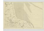
026 | [Situation] passes North of West Mains & so on West to the main road from Wigtown to KirKinner a road in good repair & good accomodation to the "East" of West Mains Farm, & the "Crook" this road was formed especially for the conveyance of shells from this shore by the Earl of Galloway, hence it takes name, |
| WEST MAINS | West Mains West Mains West Mains |
Mr J Broadfoot Map of Farm Mr C. Christison Rl Engrs [Royal Engineers] Map 1819 |
026 | [Situation] South of Shell Road & 6 chains west of East Mains and 7/8 mile N [North] by E [East] of Kirkinner A good farmhouse, two stories high built of stone with outbuildings, & Gardens attached Property of the Earl of Galloway, occupied by Mr J. Broadfoot, who holds an extensive farm of good arable land |
| EAST MAINS | East Mains East Mains East Mains |
Mr J Broadfoot Map of Farm by J. Christison Rl Engrs [Royal Engineers] Map 1819 |
026 | [Situation] South of Shell Road & 6 chains East of West Mains. Cottage house, and outbuildings built of Stone, the property of the Earl of Galloway, in the occupation of Mr Broadfoot of West Mains, this is a farm of excellent land. |
Continued entries/extra info
[Page] 2Plan 26 A -- Parish of KirKinner
Form 136 P [Page]
16 - Shell Road
7 - West Mains
7 - East Mains
Transcribers who have contributed to this page.
Bizzy- Moderator, joseph mc keown
Location information for this page.
Linked mapsheets.