OS1/35/40/11


| List of names as written | Various modes of spelling | Authorities for spelling | Situation | Description remarks |
|---|---|---|---|---|
| HIGH BORELAND | High Boraland High Borland Boreland High Boreland High Boreland |
James Milroy James Gibson Esqr. Ainslies map 1782 Plan 17 C George McHaffie Esqr. |
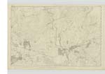
017 | [Situation] In the N.W. [North West] of the Parish of old Luce 1 1/2 miles NW. [North West] off Glenluce. A Trigl. [Trigonometrical] Station on the farm of High Boraland. The place on which it stands is not Known by any particular name |
| WATER OF LUCE | Water of Luce Water of Luce River Luce River Luce |
George Mchaffie Esqr. See Plan 17 D Thomas Williamson Hugh Campbell |
017 | [Situation] Forms part of the Eastern Boundary of Old Luce, from thence passes through the Centre of the Parish. This River runs in a southerly direction through a part of the Parish of Old Luce and falls into the Bay of Luce 1 mile S.W. [South West] of the Village of Glenluce. |
| OLD MILITARY ROAD | Old Military Road Old Military Road Old Military Road |
David Dick William Brown George McHaffie Esq. |
017 | [Situation] 1/2 mile South of Carscreugh Castle. An Old Road from Glenluce to Newtonstewart, it was constructed by the Military under the direction of Genl. [General] Wade from 1750 to 1760. It is now in bad repair and not much used. |
Continued entries/extra info
[Page] 11Parish of Old Luce
Form 136 Page
29 - High Boreland
67 - Water of Luce
67 - Old Military Road
Transcribers who have contributed to this page.
Chr1smac -Moderator, JCB
Location information for this page.
Linked mapsheets.