OS1/35/36/10


| List of names as written | Various modes of spelling | Authorities for spelling | Situation | Description remarks |
|---|---|---|---|---|
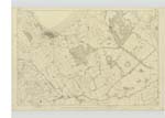
| INCH PARKS | Inch Park Inch Park Inch Parks Inch Park Inch Parks |
John Crawford James McMeikan George Guthrie Esqr. Factor Rl [Royal] Engineers Map 1819 George McHaffie Esqr. |
016 | [Situation] 1/2 Mile East by North of the Village of Inch A large tract of land divided into several tenements or Farms. Some of which are known by particular names as Clachanpluck Cairn McNillie High Barns &c. Formerly this place was a large unenclosed moor at which time it got the name Inchpark the soil is light and sandy the farms are generally Small the houses are rather of an inferior description. This tract of ground extends on the S.E. [South East] as far as Inch Village is bounded on the E [East] side by White Loch and the lands of Castle Kennedy the South boundary of it is the main road from Stranraer to Glenluce the west boundary is the farm called Sand Mill the northern part of this tract is on adjoining plan (See name List for that plan) |
Continued entries/extra info
[Page] 10Parish of Inch
Form 136
Page 32 - Inch Parks
Transcribers who have contributed to this page.
Chr1smac -Moderator, Brenda Pollock
Location information for this page.
Linked mapsheets.