OS1/35/25/3


| List of names as written | Various modes of spelling | Authorities for spelling | Situation | Description remarks |
|---|---|---|---|---|
| TARF WATER | Tarf Water Tarf Water Tarf Water Tarf Water Tarf Water "Tarbh" "Uisge" |
Map & History of Wigtown Shire James McKie Ainslie's Map 1782 Mr John McClure George McHaffie Esqr. A Bull Water Gaelic Dictionary |
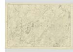
012 | [Situation] West Boundary of Parish. A small river rising out of a bog in Carrick Co. [County] of Ayrshire forming the boundary between the parishes of New Luce and Kirkcowan for the greater part of the distance (12 Miles) where it joins the Bladenoch at The S.E. [South East] Side of Kirkcowan Village. - |
| LOW ELDRIG | Low Eldrig Low Eldrig Low Eldrig Low Eldrige Low Eldrig or Eldrick Low Eldrick |
Mr. James Stroyan Mr. John McHarg Mr. Alexander Hunter Farmer List of properties George McHaffie Esqr. Ainslie's Map 1782 |
012 | [Situation] 6¼ Miles NW [North West] of Kirkcowan Village & ½ Mile East of Tarf Water. A middling farm house with out houses and a farm of land attached the property of the Marquis of Bute. |
| HIGH AIRIES | High Airies High Airies High Airries High Aires |
Mr John McHarg Mr James Stroyan Alexander Hunter (farmer) List of properties Ainslie's Map 1782 |
012 | [Situation] 5½ Miles N.W. [North West] of Kirkcowan Village and 1 Mile East of Tarf Water. A house and farm attached to Arries farm. |
Continued entries/extra info
[Page] 3Parish of Kirkcowan
Tarf water - Form 136 - Page 29
Low Eldrig - Form 136 - Page 21
High Arries - Form 136- Page 21
Tarf Water - Chalmers, the Author of Caledonia says, That this river
derives its name from an ancient Superstition, which supposes that some
waters are haunted by an apparition in the form of a Bull. hence the name.
"Airidh" A shealing; hill pasture, or summer residence for herdsman and cattle etc. Gaelic Dictionary.
Transcribers who have contributed to this page.
Chr1smac -Moderator, DANIALSAN
Location information for this page.
Linked mapsheets.