OS1/29/3/1


| List of names as written | Various modes of spelling | Authorities for spelling | Situation | Description remarks |
|---|---|---|---|---|
| BEDRULE [parish] | Bedrule | Blackwood's Map of Roxburghshire Johnston's Map of Roxburghshire Valuation Rolls of Roxburghshire |
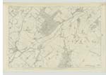
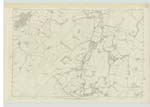
020; 026 | [Situation] In the centre of the County of Roxburgh. The name of this Parish is a corruption of Gaelic Badruchail signifying the village by the roaring stream, - the ancient modes of writing it having been Bedderul Bedderoul and Badroul and which the inhabitants still pronounce as if written Betherull, - resembling in sound that of the Gaelic original. The Parish of Bedrule is bounded on the North by those of Ancrum and Jeburgh, on the East by Jedburgh, on the South by HobKirk and on the West by HobKirk and Cavers.- There is no part of it detached nor is there within its boundaries a detached portion of another Parish.- Of somewhat oval figure, it measures from North to South upwards of 4 miles and from West to East between 2 and 3 miles and has an area of about 3,753 Impl [Imperial] Acres which consists of nearly an equal quantity of arable, pasture and muir land. The Parish throughout has an undulating surface - the richest land lying along the principal streams. From the Dunian at [continued on page 2] |
Continued entries/extra info
[Page] 1Parish of Bedrule -- County of Roxburgh
Transcribers who have contributed to this page.
Bizzy- Moderator, Skinnb1- Moderator
Location information for this page.