OS1/25/26/114


| List of names as written | Various modes of spelling | Authorities for spelling | Situation | Description remarks |
|---|---|---|---|---|
| THORTER BURN | Thorter Burn Thorter Burn Thorter Burn |
Estate Plan John Dougall Senr. [Senior] John Dougall Junr. [Junior] |
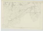
119 | [Situation ] In the S. [South] portion of the parish E. [East] Side of Eldritch Hill A small stream which forms the boundary between Cockersfauld and Knowes Farms. It taKes its rise in Green Moss near Piperstones Hill about a mile above its junction with the Clatteringford Burn. |
| THORTER BRIDGE | Thorter Bridge Thorter Bridge |
William Bain. William Oswald. |
119 | [Situation] About ¼ Mile N. [North] of CocKersfauld Hill A small stone bridge of one arch, over Thorter Burn; on the Turnpike Road leading from Dunning to Muchart. |
| COCKERSFAULD HILL | Cockersfauld Hill Cockersfauld Hill |
William Bain. Peter Massie, Shepherd, Cockerdfauld |
119 | [Situation] In the Southern portion of the parish A large hill on the farm of Cockersfauld; its surface is rough pasture. |
Continued entries/extra info
[Page] 114Parish of Dunning -- Plan 119 - 5 Trace 3
Transcribers who have contributed to this page.
Trondragirl- Moderator, Molly Miller
Location information for this page.
Linked mapsheets.