OS1/25/12/3


| List of names as written | Various modes of spelling | Authorities for spelling | Situation | Description remarks |
|---|---|---|---|---|
| DUNMORE | Dunmore Dunmore Dunmore Dunmore Dunmore Dun bo chaistel Taradoun Hill Taradoun Hill |
Peter Stewart, Tarandoun John Anderson, Gamekeeper Alexander Stewart, Glenfinlas John Stewart, Bochastle Mr. McBeath, Inspector of Poor Callander New Stat. Acct. [Statistical Account] Mr. Buchanan, Merchant Callander John Buchanan, Easter Gartchonzie |
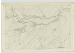
123 | A small but tolerably high hill on the farm of Taradoun. On its summit is a very entire fortification which is defended on the N. [North] & N.W. [North West] and S.W. [South West] sides by three tiers of ramparts or mounds, and on the east by the natural face of the hill which is inaccessible, rough, and rugged with outcropping rocks. Concerning it there are no traditions in the locality farther than the Authorities attribute it to the Roman period. But its shape and form is more in keeping with the ancient British fortifications. In the centre of it, a well is visible which is nearly filled. "About a mile west of Callander there remains of a fortification on the top of a hill called Dun bo chaistel, the hill of the Castle. This must have been a place of considerable strength; The face of the hill is perpendicular rising to the height of about ? and quite inaccessible on the south. The Gateway and three tiers of ditches and mounds are distinct upon the top. The mounds are strengthened with large stones, and within was a sunk well, which has been filled up as cattle were liable to fall into it. In the plain of Bochastle and in the immediate vicinity of this fortification, is an Artificial bank of earth and stone, which perhaps was erected for the purpose of reducing this fort, but we have no authentic record on this subject." New Stat Acct. [Statistical Account] |
| FORT [Dunmore] | 123 | [Dunmore] A small but tolerably high hill on the farm of Taradoun. On its summit is a very entire fortification which is defended on the N. [North] & N.W. [North West] and S.W. [South West] sides by three tiers of ramparts or mounds, and on the east by the natural face of the hill which is inaccessible, rough, and rugged with outcropping rocks. Concerning it there are no traditions in the locality farther than the Authorities attribute it to the Roman period. But its shape and form is more in keeping with the ancient British fortifications. In the centre of it, a well is visible which is nearly filled. | ||
| WELL [fort-Dunmore] | 123 | [Dunmore] A small but tolerably high hill on the farm of Taradoun. In the centre of it, a well is visible which is nearly filled. |
Continued entries/extra info
[Page] 3123-4 -- Parish of Callander
[Notes:]
Dunmore is the general expression. It is not known by
the name Dun bo chaistel.
"The remains of this Camp may still
be seen, near Bochastle, about 15 miles
West, South-West from the Station at Ardoch.
The judicious position of the Camp, is very
apparent; as it guarded, at once, two
important passes into the West Country &c"
Chalmer's Caledonia
This Fort is evidently not Roman -
It resembles on a small scale the
form of the celebrated Fort of the
White Catterthun in the Parish of Menmuir, near Brechin
[initialled] JB
Lt.Col. [Lieutenant Colonel]
Transcribers who have contributed to this page.
Alison James- Moderator, Brenda Pollock
Location information for this page.
Linked mapsheets.