OS1/24/36/29


| List of names as written | Various modes of spelling | Authorities for spelling | Situation | Description remarks |
|---|---|---|---|---|
| TOWN WALL [Peebles] | Town Wall Town Wall |
Mr William Blackwood Mr R Stirling |
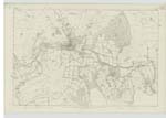
013 | [Situation] Eastern Extent of the town of Peebles This was a strong built wall about 4 feet in thickness and about 8 or 9 feet in height which was erected round the Town as a means of defence against the invasion of an enemy. Commencing at the West end of the High Street where there was a gate called West Port, it went in a Northerly direction towards the Eddleston Water it then turned along the East side of the Eddleston Water as far as Usher's Wynd at which place it tooK an Easterly direction Keeping the South side of the Wynd and crossed the North-gate near the British Linen Companys Bank, at which place there was a gate called North Port, the wall keeps still an Easterly direction till it goes to the East end of the garden belonging to the British Linen Company's Bank at which place there is the remains of Watch Tower, the wall then takes a Southerly direction, going along the back part of some gardens, till it crossed the east end of the Town, when as gate called the East Port was erected the wall still continues in the Same direction Keeping the West side of the Old Vennel till it reaches Tweed Green. It the turns Westwards Keeping on the North side of Tweed Green till till it reaches near to Tweed Bridge, at which place it takes a Northerly direction to where the West Port before mentioned stood at the West end of the High Street. A great portion of the Old Wall is at present standing |
Continued entries/extra info
[Page] 29Town of Peebles
In the eastern Section of the town may likewise be observed
some portions of the wall built as a defence against sudden
invasion. The line of the wall Can be satisfactorily traced
Starting from Portbrae, where there was a gate leading to
the bridge, the wall was conducted along the South side of the
town. Ascending to the East-Port, it proceeded in a northerly
direction, so as to include some gardens in the Northgate;
and it is at this place that a considerable part remains till
the present day. The wall crossed the Northgate, near the
building now occupied by the British Linen Company's Bank
and ran down the side of the opposite lane Called "Usher's Wynd",
to the Side of Eddleston Water. It then Proceeded along the
foot of the gardens: passed the foot if the Brig-gate, also the foot of
St Michael's Wynd, an alley with a fostered, leading to what seemed
to have been a ford across Eddleston
Water to the Kirk-road now called BiggiesKnowe; the wall then proceeded
westwards, so as to form a connection at
over
Transcribers who have contributed to this page.
Bizzy- Moderator, eddlerose
Location information for this page.
Linked mapsheets.