OS1/23/2/138


| List of names as written | Various modes of spelling | Authorities for spelling | Situation | Description remarks |
|---|---|---|---|---|
| QUOYNESS BROUGH | Quoyness Quoyness Quoyness |
Rev John Dangerfield Minister of Lady William Learmonth Farmer Elsness William Slater Shoemaker Silverhall Archaeologia Scotica p.94 |
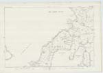
081 | A Mound situated on the west side of Sty Wick and nearly 1 mile south west of the Farm of Elsness. It is close to the sea and within a few feet of High Water Mark. In its present ruinous condition the diameter is 63 feet and height 12 1/2 feet and upon being excavated Graves or Kists were found containing human remains. The Mound presents the usual appearance of a large Brough but Mr Farrer late M.P. for South Durham who made some excavations in July 187 says "I am disposed to think that, until further investigation has been made, it would be difficult to determine positively whether the mound was in its original state, a burial place [underlined]. It may have been a Brough[underlined] and the space between the inner and outer walls which I suppose to have been an open area, may have been a mass of rude walling constructed with a view of supporting the building in which the graves are found." It is on the property of the Trustees of James Traill Esq of Balfour and Trenabie. |
| TAING OF CORKATAE | Taing of Corkatae | Rev John Dangerfield Minister of Lady William Learmonth Farmer Elsness William Slater Shoemaker Silverhall | 081 | Point of low water rocks on the west side of Sty Wick and about one eighth of a mile north east of Quoyness. |
Transcribers who have contributed to this page.
MoragSinclair
Location information for this page.
Linked mapsheets.