OS1/23/2/137


| List of names as written | Various modes of spelling | Authorities for spelling | Situation | Description remarks |
|---|---|---|---|---|
| AUGMUND HOWE | Egmount Howe Augmund Howe Augmunds Howe |
Rev John Dangerfield Minister of Lady William Learmonth Farmer Elsness William Slater Shoemaker Silverhall Re-submitted Stat. a/c of Scotland |
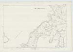
081 | A mound having the appearance of a Pictish building on the west side of Sty Wick and nearly 1/4 of a mile north east of Els Ness. No information could be obtained regarding it but its proximity to the Brough of Quoyness would seem to imply some connection therewith. "On the northern extremity of this cape (Elsness) there is a brough or fort, called Augmund's Howe. It is now in ruins, and overgrown with grass and weeds." Statistical Account of Scotland. |
| GEO OF HOLMSOUND | Geo of Holmsound Geo of Holmsound Geo of Holmsound |
Rev John Dangerfield Minister of Lady William Learmonth Farmer Elsness William Slater Shoemaker Silverhall |
081 | A creek a short distance north of the south east entrance to Kettletoft Bay and 3/4ths of a mile south of the farm of Elsness. |
| RONNEY | Ronney | Rev John Dangerfield Minister of Lady William Learmonth Farmer Elsness William Slater Shoemaker Silverhall |
081 | A point of Low water rocks on the south side of Holm Sound and forming the east point of the Holm of Elsness. |
| TUMULI [NW of Els Ness] | Tumuli | From personal obseervation of Lieut. F. J. Day while finally examining the Plan of Orkney. | 081 | Applies to a number of mounds lying to the north west of Els Ness & a short distance W. of Augmund's Howe. They are most probably the remains of the extensive settlement. Mentioned in Statistical Account of Scotland. |
Transcribers who have contributed to this page.
MoragSinclair
Location information for this page.
Linked mapsheets.