OS1/21/55/63


| List of names as written | Various modes of spelling | Authorities for spelling | Situation | Description remarks |
|---|---|---|---|---|
| ROMAN ROAD [Stonehouse parish] | Roman Road (remains and site of). Roman Way. Virinal Road |
New Statistical Account. Forest's Co. Map. Jas. Hamilton, Bogside. J. Thomson, Dykehead. R. Leiper, St Lawrence Chapel. D. McAllum, Over Tweedieside. John Allison, Goslington. Thos. Hamilton, Inspector of Poor. Caledonia Romana (see description of "tumulus", plans 24-9). Chalmers Caledonia, Vol 1 p73. |
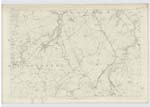
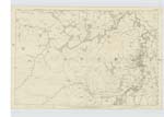
024; 030; 031 | "The old Roman Military Road from Ayr to Edinburgh, which runs through this parish, commonly known to the people as the "Deil's Causeway". This road, in some places, is still outire, very rudely paved with large stones; in other places it has been completely erased by the country people". New Statistical Account. The remains of this Roman Road, where it enters the parish on the western boundary, coming from "Drafan", in Lesmahagow Ph, may be distinctly traced by some of the causewayed stones appearing on the surface of the ground. These remains exist where the land is bad, or has been planted with trees. As stated by Mr. J. Hamilton of Bogside, and Mr. R. Leiper of "Chapel", both nearly 90 years of age, the Roman Road was used by horsemen between 70 and 80 years ago, and they, consequently remember the site, where owing to cultivation, it is now erased. At those places written "Site of Roman Road" (shown in a red dotted line) the site has been pointed out by the above named authorities. None of the causewayed stones are to be seen at these places marked "site". At places written "Remains of Roman Road", (shown in a black dotted line) the large rough stones of the causeway appear, at intervals, on the surface of the ground. On no part of the line of road, do causewayed stones appear regular and compact, numerous stones have been taken from every part of it in this parish, - as pointed out on the ground, by Mr.J. Hamilton of Bogside, Mr. J. Thomson of Dykehead, from the point where it enters the parish, on the western boundary, to the Ph. Road (xx1v-14 trace 4) the remains are seen in a plantation after passing through which into the arable ground, it forms a strip of rough pasture in two arable fields. From the west side of Ph. Road - xx1v-14 trace 4, to within about 9 chains south east of "St Lawrence Chapel", the remains of the causeway |
Continued entries/extra info
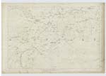
"From the station at "Castledykes" (in Carstairs Ph), there went off a original road, athwart Clydesdale, which was , perhaps, intended to form a communication, between the western road and the estuary of the clyde, this vicinal road, probably, passed the clyde, near Lanark", thence "leading by "Tanhill", along the north side of "Blackwood" inclosures. (both in Lesmahagow Ph) to Dins-hill: it thense passed to the south of Hazalaslew, crossing "Kype Water" at Sandford (near the boundary between Stonehouse, and Avondale) and coarsed along the south side of Avondale, by Wellsley, and Westlingbank, towards the gorge at Loudon-hill",Chalmer's Caledonia. Vol 1 P. 138
The site or remains of Roman milestones on this road in Stonehouse Ph., are not known, or have never been heard of.
Transcribers who have contributed to this page.
w smith
Location information for this page.