OS1/20/158/18


| List of names as written | Various modes of spelling | Authorities for spelling | Situation | Description remarks |
|---|---|---|---|---|
| LITTLE ROSS | Little Ross Little Ross Little Ross |
Thomas Ritson James Campbell Ainslies' Map 1820 |
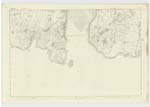
054 | [Situation] About 1 3/4 Miles S. W. [South West] of Balmae An Island in the Mouth of Kirkcudbright Bay about 25 Chains in length 15 in breadth Its soil consists of rocky arable land and on its Summit is a [Signal] pole used as a Trigl. [Trigonometrical] Station. The Island is indented [round] by several small creeks or bays, and its Shore consists chiefly of rocks, portions of which are very bold and [--] precipitous. There is also on it a Lighthouse and dwelling house for Keepers, and near its Northern end is a Stone [built] tower about 20 feet in height used as a beacon.-- The Summit of this Island commands an extensive prospect of the adjacent country, a wide expanse of the Irish Sea, the Mountain ranges of Cumberland on the East, the Isle of Man on the S. S. [South South] West, and the Coast of Wigtownshire is a striking feature on the S. S. [South South] West Side. -- |
Continued entries/extra info
[Page] 18Parish of Borgue
Form 136 Page
86 Little Ross
Transcriber's notes
Some letters lost in the margin. Transcriptions feedback form sent 11/04/16.Transcribers who have contributed to this page.
Skinnb1- Moderator, Nellie- Moderator
Location information for this page.
Linked mapsheets.