OS1/20/119/10


| List of names as written | Various modes of spelling | Authorities for spelling | Situation | Description remarks |
|---|---|---|---|---|
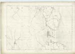
| CAERLAVEROCK POINT | Caerlaverock Point | William Hunter n & s Newfield James Irvine n & s Blackshaw |
041 | A headland projecting into the East Side of the Solway Frith off the farm of Greenhead. it is quite flat And of nearly A triangular Shape the foreshore Around it Consists of Inks And A few Small flat rocks, on it is a Trig [Trigonometrical] Station] Called by Trig [Trigonometrical] Party 'Killaverick' |
| BLACKSHAW BANK | Blackshaw Bank | William Hunter n & s Newfield James Irvine n & s Blackshaw |
041 | A large tract of Sandbank lying between the Cgannel Stream of the River nith, the Low Water mark of the Solway Frith, And the High W. [Water] Mark On the east side of the former it extends on the South Side as far as Lochar Water i.e. outside of this Plan,It is studded here and there With Stake Net Fisherys by which Salmon Hake And Herrings are usually in there respective Seasons Are taken, it is Cover'd by every tide And on it is a Trig [Trigonometrical] Station] Call'd by Trig [Trigonometrical] Party Blackshawbank. |
Continued entries/extra info
[Page] 10List of Names collected by Thomas Smith C. Asst. [Civilian Assistant]
Plan 41A Trace 1
Parish Caerlaverock
Object
Caerlaverock Point - A headland
Blackshaw Bank - A Sand Bank
[Signed]
Thomas Smith
26th. October 1850
Transcribers who have contributed to this page.
DANIALSAN
Location information for this page.
Linked mapsheets.