OS1/20/101/9


| List of names as written | Various modes of spelling | Authorities for spelling | Situation | Description remarks |
|---|---|---|---|---|
| CLANERY HILL | Clanery Hill Clanery Hill Clanery Hill |
John Burnie John Garroch See Name List Plan 36C. |
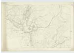
036 | [Situation] About 13/4 miles W. N, W. [West North West] of Craig (house) A small hill on the farm of Clanery, its Surface Consists of RocKy heathy pasture, On its Summit is a Trigl. [Trigonometrical] Station Called by Trigl. [Trigonometrical] Party "Clanery" |
| FALBAE BURN | Falbae Burn Falbae Burn Falbae Burn Falbae Burn Falbae Falbae |
John Burnie John Garroch Ainslies Map 1820 Map of County Valn. [Valuation] Roll - 1819 Valn. [Valuation] Roll - 1819 Anct. [Ancient] |
036 | [Situation] Running in a Southerly direction from Clanery Hill & Passing the W. [West] Side of Falbae Plantn [Plantation] A Small Stream or burn taKing its rise on the farm of Clanery and Running in a S. [South] Easterly - direction through the farm of Falbae (hence the name) to its influx with Moneypool Burn, |
Continued entries/extra info
Parish of KirKmabrecK -- [Page] 9Form 136 Page
25 Clanery Hill
25 Falbae Burn
Transcribers who have contributed to this page.
Molly Miller
Location information for this page.
Linked mapsheets.