OS1/18/5/129


| List of names as written | Various modes of spelling | Authorities for spelling | Situation | Description remarks |
|---|---|---|---|---|
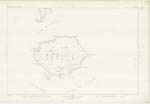
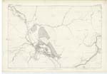
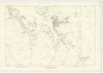
| BEINN A' CHÀRNAIN | Beinn a' Charnain Beinn a' Charnain Peak of Pabbay Pabbay Peak Ben a' Harnine Ben na Charnan |
Angus Morrison, Ferryman, Obb, Harris A.A. Carmichael Esqr. Admiralty Chart Blacks Map O.E. [Old Estate] Map D. McDonald Berneray |
021 | This name is applied to a hill of ordinary size. It is 638 feet above the level of the sea, being the most prominent part of the island of Pabbay. It is covered (even to the summit) with excellent pasture. |
| BAILE-FO-THUATH | Baile-fo-thuath Northtown |
Angus Morrison, Ferryman, Obb, Harris A.A. Carmichael Esq. D. McDonald Berneray |
This name signifies "North town" and is applied to a number of ruins of house formerly occupied by tenants on this island, Pabby. | |
| SCARASDALE POINT | Scarasdale Point Ru Sgarasdale Ru Scarrisdale |
Angus Morrison, Ferryman, Obb, Harris A.A. Carmichael Esq. Admiralty Chart Black's Map Old Estate Map |
021 | Is applied to a rocky point on the north coast of the island of Pabbay 50 Chains North-west from the summit of "Beinn a' Charnain" Signification "Sgarasdale point". |
Continued entries/extra info
[Page] 129Western Islands -- County of Inverness
Transcribers who have contributed to this page.
Alison James- Moderator
Location information for this page.