OS1/10/48/76


| List of names as written | Various modes of spelling | Authorities for spelling | Situation | Description remarks |
|---|---|---|---|---|
| PERCEIVING BURN | Perceiving Burn Perceiving Burn Perceiving Burn |
Revd. [Reverend] Richard Sanders Mr. John Richardson farmer Mr. Johnstone of Northburn |
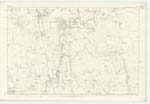
051 | [Situation] Passes immediately to the West of Northburn A small shallow rivulet which has its source on the lands of Wyliehole, runs in a N.W [North West] direction and falls into Milk Water |
| TUMULUS [Tundergarth] | Tumulus Tumulus Tumulus |
Revd. [Reverend] Richard Sanders Mr. William Reid farmer Mr. John Sanders |
051 | [Situation] 54 chains N.E. [North East] from Tundergarth Church. A small circular Knoll of slight elevation supposed to be a burying ground. "An urn was extracted containing bones." |
| PERCEIVINGBURN BRIDGE | Perceivingburn Bridge Perceivingburn Bridge Perceivingburn Bridge |
Revd. [Reverend] Richard Sanders Mr. John Richardson Mr. William Reid |
051 | [Situation] Over Perceiving Burn. A small stone bridge of one arch across Perceiving Burn |
Continued entries/extra info
[Page] 76Parish of Tundergarth -- Plan 51.3 Trace 3
[Signed] M. Donohue
Febr. [February] 1857
Transcribers who have contributed to this page.
CorrieBuidhe- Moderator, Brenda Pollock
Location information for this page.
Linked mapsheets.