OS1/10/48/77


| List of names as written | Various modes of spelling | Authorities for spelling | Situation | Description remarks |
|---|---|---|---|---|
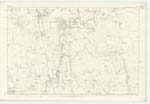
| Site of FORT [Tundergarth] | British Fort (Site of) British Fort (Site of) British Fort (Site of) |
Revd. [Reverend] Richard Sanders Mr. Johnstone of Gibson Mr. William Reid of Bankhill |
051 | [Situation] 62 chains N.E. [North East] from Tundergarth Church The vestiges of an ancient camp or British fort now obliterated by the Plough. It is supposed to have been a Roman Camp, the eye can still perceive a slight circular elevation which occupied the position on level ground it is slightly hollowed in the inside. "The party who ploughed it pointed out the site, and states that its shape was round." Consequently it must have been a Celtic or British Fort. |
Continued entries/extra info
[Page] 77Parish of Tundergarth -- Plan 51.3 Trace 3
[Signed] M. Donohue
Febr. [February] 1857
Transcribers who have contributed to this page.
CorrieBuidhe- Moderator, Brenda Pollock
Location information for this page.
Linked mapsheets.