OS1/10/48/2


| List of names as written | Various modes of spelling | Authorities for spelling | Situation | Description remarks |
|---|---|---|---|---|
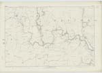
| TUNDERGARTH [parish] | Tundergarth Tundergarth Tundergarth |
J & W Walker's Map of Scotland Crawford's Co. [County] Map Johnston's Co. [County] Map |
035; 043; 044; 051; 052 | [Continued from page 1] to Lockerbie, another line diverging from this road runs South to Ecclefechan. The Caledonian Railway runs across the Parish near the Southern extremity. There are no manufactories and no minerals are wrought. The Parish is entirely rural, the lands are much divided, there being about 30 proprietors, there are one Parish Church and a School situate towards the Southern extremity. Population about 600. A Roman Road is still traceable near the Southern extremity of the Parish. "In regard to Antiquities" says the New Statistical Account, "the oldest seemingly of which this Parish can boast is a Roman Road, discovered a few years ago on the North side and passing from the Roman Camp on Birrenswark Hill in a direction N.W. [North West]." The situation "on the North side" is a mistake as is at once evident when the position of Birrenswark Hill to this Parish is considered, also from the following in the New Gazetteer of Scotland "the principal Antiquity is part of the Roman Road from Burnswark Hill, which overlooks the South-West border to Upper Nithsdale." This Roman Way led to Gallaberry Hill in Dryfesdale where two lines diverged respectively through Nithsdale and Upper Annandale. Forts occur throughout this Parish which the people of locality assume are of ancient British origin. The temporary nature of these Camps cannot however be said to bear out this construction and it is still disputed to what period these Works belong as appears from the following in the New Statistical Account of Dumfries "There are still in many places small entrenched Camps or Birrens as they are called. They are all on elevated situations; generally of a round form, very prominent and in good preservation; and they consist of a strong vallum and fosse, without any outworks. The area seldom exceeds an acre, and is often less. It is conjectured that they were constructed during the long feuds and border wars by the Septs or Lairds, to protect themselves and cattle from the English and from one another. It is probable, however, that some of these may be of an earlier date and may be what are called British Fortifications; many of them still retain the Name of Castle. In some towards the lower part of the Parish urns containing bones have been found". There are some remains of a Druidical Circle near the centre of Parish, which consist of seven stones called in the district Seven Brethern "Among these remains bones have been found but whether human or not has not been ascertained" New Stat. Acct. [Statistical Account]. The Site of a Castle on that of outhouses attached to Tundergarth farm house has also been shewn. "The Manor of Tundergarth having anciently belonged to the family of Johnstone who had here now an extinct Castle, the Name of Johnstone is now the prevailing one here &c." Gazetteer of Scotland. |
Continued entries/extra info
[Page] 2Parish of Tundergarth -- Co. [County] of Dumfries
Transcribers who have contributed to this page.
CorrieBuidhe- Moderator, Brenda Pollock
Location information for this page.
Linked mapsheets.