OS1/10/43/14


| List of names as written | Various modes of spelling | Authorities for spelling | Situation | Description remarks |
|---|---|---|---|---|
| GLASGOW AND SOUTH-WESTERN RAILWAY | Glasgow and South-Western Railway | James Scott John Richardson John Hill |
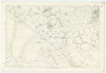
56; 61; 62 | [Situation] From near the Nn [Northern] point of the Parish running S,E,E, [South East East] A line of railway between Glasgow & Carlisle. Passes through this parish in a South-western direction |
| ROADEND | Roadend Roadend Roadend |
James Scott Registration Rolls Mr Garvine - Slethat |
056 | [Situation] About 2 3/4 mile N W [North West] from Ruthwell Village, A cottage at the end of Howthat occupation Road - Sometimes called Bowerhouses Cottage, as the triangular piece of land attached, between the public road & the Railway, formerly belonged to Bowerhouses. |
| BOWERHOUSES COTTAGE | Bowerhouses Cottage | James Scott John Richardson Dr [Doctor] Broach |
056 | [Situation] About 2 1/2 mile N,W, from Ruthwell Village, An old cottage within the farm of South Bowerhouses - Some times called Roadend from its standing at the end of the road leading to the farm |
| SLETHAT BURN | Slethat Burn Slethat Burn Slethat Burn Slothat |
George McLean William McLean James Scott Johnstone's Co [County] Map |
056 | [Situation] 1/2 mile N,W [North West] from Slethat running S,W, [South West] A small stream having its source 1/4 Mile E [East] of Howthat Bridge, It flows in Southerly direction and falls into Mill Burn W, [West] of Ruthwell Station, |
Continued entries/extra info
[Page] 14Parish of Ruthwell -- Plan 56-15 -- Trace 2
[Signature] W. Paterson c/a [civilian assistant]
Transcribers who have contributed to this page.
Moira L- Moderator, Maggie F
Location information for this page.
Linked mapsheets.