OS1/10/38/119


| List of names as written | Various modes of spelling | Authorities for spelling | Situation | Description remarks |
|---|---|---|---|---|
| REDGILL CRAIG | Redgill Craig | James Johnstone David Johnstone David Brydon |
010 | A Projection of rocks situated a short distance North West from the summit of Saddle Back |
| UPPER TORR GILL | Upper Torr Gill | James Johnstone David Johnstone David Brydon C Stewart Esq (Hillside) |
010 | A narrow water channel, situated a little below the Redgill Craig |
| UPPER COOMB SIKE | Upper Comb Syke | James Johnstone David Johnstone David Brydon |
010 | A small runner that gathers in a hollow place, and runs into the Blackhope Burn |
Continued entries/extra info
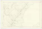
Page 119 Parish of Moffat Sheet 10.5 Trace 2Redgill Craig situation Near the Northern extremity of this Parish
Upper Torr Gill situation At the South Eastern extremity of Redgill Craig
Upper Coomb Syke situation 17 Chains South West from Upper Torr Gill
Coomb - Scotch a Comb or side of a hill For Authorities See Page 21
John Jane Sapper Royal Engineers
Transcribers who have contributed to this page.
stellas
Location information for this page.
Linked mapsheets.