OS1/10/38/118


| List of names as written | Various modes of spelling | Authorities for spelling | Situation | Description remarks |
|---|---|---|---|---|
| COLD GRAIN | Cold Grain | James Johnstone Capplegill David Johnstone Capplegill David Brydon Bodsbeck |
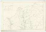
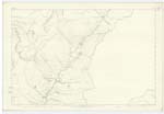
009; 010 | A small stream having its source in a hollow at the foot of Hartfell Craig, After rumbling South Eastward for some distance over a very rugged bottom, it forms a confluence with the Whirlie Gill burn, the two streams form the Blackshope Burn. |
| WHIRLY GILL | Whirlie Gill Whirley Gill |
James Johnstone Capplegill David Johnstone Capplegill David Brydon Bodsbeck C Stewart Esq Hillside |
010 | A narrow but exceedingly picturesque watercourse, the stream which passes through it gathers among peat hags at the North boundary of the parish, it runs South Westward until it joins the Cold Grain. |
| BLACKHOPE BURN | Blackhope Burn Blackhope Burn |
James Johnstone Capplegill David Johnstone Capplegill David Brydon Bodsbeck Walter Johnstone Archbank |
010 | Is formed by the confluence of the Cold Grain, and Whirly Gill and runs almost in a direct line for about 3 miles to the Moffat Water, at Bodsbeck. The sides of the Hope or hollow through which the stream passes are said to be the steepest and most rugged in the South of Scotland |
Continued entries/extra info
Page 118 Parish of Moffat Sheet 10.5 Trace 2Cold Grain situation From Hartfell Craig South South East to Blackshope Burn
Whirly Gill situation About 11 Chains West from Redgill Craig
Whirly See Page 61
Blackshope Burn situation From the junction of Cold Grain and Whirly Gill Burn South East to Moffat Water
John Jane Sapper Royal Engineers
Transcribers who have contributed to this page.
stellas
Location information for this page.