OS1/10/36/1


| List of names as written | Various modes of spelling | Authorities for spelling | Situation | Description remarks |
|---|---|---|---|---|
| LOCHMABEN [parish] | Lochmaben Lochmaben Lochmaben |
Walker's Map of Scotland Johnstone's Map of Dumfriesshire Crawford's Map of Dumfriesshire |
042; 050; 051; 056 | The Name of the Parish is of doubtful origin. Tradition reports that a Nunnery existed at an early age on an Island in one of the largest lochs from which circumstance Gaelic Maigdenn is supposed to be the derivation - thus to signify the Loch of Maidens. Dr [Doctor] Jamieson asserts however that such is a wrong interpretation of the Name as Maigdian is not a pure gaelic word but borrowed from the Gothic. The mude [mode?] of orthography as P [per] an old deed granted by Robert I to Carruthers of Mussald is "at our Manor of Lochmalban". If this be the original spelling, the probability is that the name is compounded of "loch, maol and ben or ban" - "the Loch of the bald Eminence". - Bald might with propriety be interpreted - destitute of foliage, for even at this date, the great desideratum in this Parish are Trees. |
Continued entries/extra info
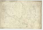
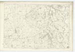
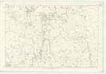
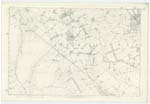
Situation: Towards SWn extremity of Dumfriesshire between the Parishes of Johnstone, Dryfesdale, Applegarth, Dalton, Mouswald and Torthorwald.Extra info: The Parish of Lochmaben is bounded on the North by that of Johnstone, - on the East by Applegarth, Dryfesdale and Dalton, on the South by Dalton and Mouswald, - And on the West by Torthorwald, Tinwald and Kirkmichael. - The Boundaries at North-West corner are defined by Kinnel Water, - at the North, undefined and by wall and drain, - on the East principally by River Annan, a small portion of Dryfe Water, small [?runners], hedge paling and bank, - on the South by hedge, paling, bank, wall and Rangegill Burn, - on the West by wall, bank, Raemoor Burn, drain, Water of Ae and also are undefined+. - The shape is pretty compact and approaches to that of an oblong with points projecting 1 and 1 1/2 mile respectively at the South-west and South-east corners. -The Statistics state the extreme length to be 10 miles and breadth 3 miles and to contain 16 3/4 square miles or 10,750 a. The length however does not exceed 8 7/8 miles and mean breadth 2 1/3 miles, making the Area about 17 3/4 miles or 11,360 Impl [Imperial] Acres, of which 9,385* may be arable and lea or meadow land, 1350 permanent or holm pasture, 120 wood and 500 Moss And irreclaimable moor. - The surface may be considered plain and level, the only exception being towards the West where it was to a height of about 500 feet, but which can scarcely be called hilly for the entire soil is cultivated so gentle is the acclivity. - The soil varies, towards the west, it is light, gravelly and cold, the average part of which is £1.2.6 P [per] acre, - Along the banks of the principal Streams it is a rich alluvial loam, which is greatly enriched by deposits from the frequent overflows of these Streams. - The soil in the neighbourhood of the Town of Lochmaben is dry and productive, the average rent of which is £2.15.0 P [per] Acre. - Patches of Moss frequently occur from which the inhabitants procure peat for fuel. - Towards the South and South-West the land is partly Moor. - The whole land is well enclosed and the Farm Steadings generally are Commodious and in good repair. - There is an abundant supply of Water, there are 9 Lochs vizt. Castle Loch which has an Area of 220 Acres, Halleaths or Broomhill Loch 80 Acres, Kirk Loch 60 Acres, Hightae Loch 52 Acres, Mill Loch 32 1/2 Acres, Upper Loch 14 Acres, Grassyard Loch 3 Acres and two others Blind Lochs on Nn [Northern] Parish Boundary of 3 Acres. - All these Lakes with the excemption of the last three are clustered near centre of Parish. The larger Streams are Kinnel Water from N W point of Parish running S.E. to River Annan, River Annan on En [Eastern] Boundary running South, Dryfe Water also on En [Eastern] Boundary and Water of Ae (also) on Nn [Northern] Boundary: there Are also numerous Springs, wells and runners the Water of which along with that of the Lochs is used with safety by the inhabitants for culinary purposes. Coal or other mineral has never been discovered. - Red Sandstone is regularly and extensively worked in Corncockle Quarry and Redhall Quarry. - No Manufactory exists.
*The Areas of Castle, Halleaths, Kirk, Upper, Mill and Hightae Lochs are included in this and the wood, - 458 acres falling to be deducted there from. -
+There is no detached portion of Lochmaben within the Boundaries of Another Parish, nor within its limits as above described a portion of any other Parish
Transcribers who have contributed to this page.
LucyG, DANIALSAN
Location information for this page.