OS1/10/36/186


| List of names as written | Various modes of spelling | Authorities for spelling | Situation | Description remarks |
|---|---|---|---|---|
| ROCKHALLHEAD MOOR | Rockhallhead Moor Rockhallhead Moor Rockhallhead Moor |
John Copeland David McRobert Thomas Richardson |
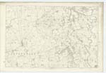
050 | [Situation] In S.Wn. [South Western] district of Parish. An extensive tract of high uncultivated moorland, the property of the Marquis of Queensberry. John Copeland occupant. |
| SHAW BURN | Shaw Burn | Trace 5. See Common Plan Mouswald. | 050 | [Situation] At S.Wn. [South Western] point of Parish. A Stream issuing from a Small Pond. [] a run of one mile through Mouswald Parish and falling into a Mill-dam at Dumfries & Annan Road where [] bears the name of Rockhall Burn to its junction with Wath Burn |
Continued entries/extra info
[Page] 186Parish of Lochmaben
Plan 50.14 Trace 3
[Signed] Philip Munro Pte.R.S.M. [Private Royal Sappers & Miners]
Transcribers who have contributed to this page.
Andrew Armstrong
Location information for this page.
Linked mapsheets.