OS1/10/29/3


| List of names as written | Various modes of spelling | Authorities for spelling | Situation | Description remarks |
|---|---|---|---|---|
| SHINNEL WATER | Shinnel Water Shinnel Water Shinnel Water Shinnel Water Shinnel Water The Shinnel Shinnel Water |
Crawford's Co. [County] Map Black's Co. [County] Map Mr Brown Johnstone's Co. [County] Map Dr. [Doctor] Singer's Survey Stat: Acc: [Statistical Account] of Dumfries Fullarton's Gazetteer |
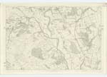
031 | [Situation] No. 1 on Trace 1. On the North-Western Parish Boundary A stream through this Plan. It rises in two small head-waters respectively at Allan's Cairn and Blackhill on the boundary with Kirkcudbright, has a Course of about 12 miles and falls into Scar Water less than a mile above Penpont. Along most of its Course the Scenery is charmingly picturesque. |
| SCAR WATER | Scar Water Scar Water Scar Water Scar Water Scarr Water The Scarr The Scar The Scarr or Skarr Skarr Water Scar Water Scaur Water |
Crawford's Co. [County] Map Black's Co. [County] Map Mr. Brown Dr. [Doctor] Singer's Survey J & C Walker's Map Stat: [Statistical] of Penpont Parish Stat: Acc: [Statistical Account] of Dumfries Fullarton's Gazetteer Johnstone's Co. [County] Map Revd. [Reverend] Mr. Menzies Account of Parish in Gazr. [Gazetteer] of Scotland |
031 | [Situation] No. 4 on Trace 1. On the North and North-Eastern Boundary of Parish. A stream through this Plan. It rises on the East side of Black Hill and falls into the Nith about 3/4 of a mile below Keir Church. This Stream probably derives its name from the nature of the banks in some parts of its course, for it seems to be no other than "Scar or Skar," a north country word signifying "a bare and broken rock on the side of a river." |
Continued entries/extra info
[Page] 3Parish of Keir -- Sheet 31/1 Trace 1
[Signed] M Donohue Civil Assist. [Civilian Assistant]
Transcribers who have contributed to this page.
CorrieBuidhe- Moderator, auntylexa
Location information for this page.
Linked mapsheets.