OS1/10/29/2


| List of names as written | Various modes of spelling | Authorities for spelling | Situation | Description remarks |
|---|---|---|---|---|
| KEIR | Keir Keir Keir Keir Keir Keir Kire |
Chalmers' Caledonia The Stat. Acc. [Statistical Account] of Dumfries Fullerton's Gazetteer Dr. [Doctor] Singer's Survey Johnstone's Co. [County] Map Valuation Roll of Parish Pennant's Tour |
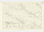
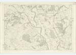
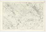
030; 031; 040 | [Continued from page 1] superficial Area is only about 11 Square Miles, or roughly computed about 7040 Imperial Acres, and which may be said to consist of about 2,300 acres of arable land, 550 meadow land, 1800 pasture and 500 growing Wood, the rest for the most part being incapable of profitable Cultivation. The principal land proprietors are The Duke of Buccleuch, Mr. Hunter Arundell of Barjarg T.S. Gladstone of The Capenoch, - Copland of Blackwood a minor and George Haggan of Waterside also a minor. Most of the Parish is a variegated and regular descent from a hilly summit having an alluvial Soil, it is Conjectured to have been anciently the bed of the River Nith, when pent up by an obstruction on the South. The Parish generally is highly cultivated and along the Streams rich and fertile and well protected by embankments exist. It exhibits throughout pleasing and finely diversified landscapes these are secondary in consideration when compared to the view obtained from Blackwood Hill which [has a] most expansive and powerful description - lifting the eye along all the brilliant and exulting valley of the Nith is at once presented all the richest and highly diversified parts of upper and lower Nithsdale, - screened extremity by the Mountain Chain of the of the lowlands of Scotland and at the other by the Cumberland hills. Streams intersect the Parish, the principal of which are the Nith the Scarr the Shinnel and Allanton Burn, - six, respectively of about one mile in length flow in almost parallel and regular intervals into the Nith and Scarr. Keir, Capenoch and Blackwood Hills rise to an elevation of from 800 to 900 feet. There are two quarries respectively at [--] and Barjarg, but they are worked at considerable Expense in consequence of the want of coal in the Parish, and another drawback is that the cover is great and the superincumbent shale so little tenacious that it requires to be all removed. Keir Hill and Barjarg are the villages or rather hamlets, the former being noticeable only for its appearance and being the Site of the Parish Church, a neat edifice, accommodating 440 Sitters. This Church is like many more in the County most inconveniently situated for the Parishioners being at [the] end of the Parish and only 1 1/4 mile from that of the adjoining Parish of Penpont. The Minister's stipend averages about £230 with [--] Manse and glebe of 10 Acres, the latter valued at £18 per Annum. There are also two Parish Schools in which the usual branches of education [--] the aggregate salaries in which are £55.13/4d. which include fees. The Population in 1831 was 1804 and amount of assessed Property in [??] £3675. Eight and a half miles of Turnpike run through the Parish, Viz. 7 on the road from Dumfries to Penpont, 1 on that from Penpont to Glencairn and 1/2 a mile from Auldgirth Bridge to the foot of the Parish. There are no remains of antiquities and the only features of connection therewith are the Sites of St. Brigid's Chapel at Kirkbride, and that of the Fort or Tower said to have given name to the Parish. [Signed] J B Innes c/a [civilian assistant] |
Continued entries/extra info
[Page] 2Transcribers who have contributed to this page.
CorrieBuidhe- Moderator, georgelaidlaw
Location information for this page.