OS1/10/29/1


| List of names as written | Various modes of spelling | Authorities for spelling | Situation | Description remarks |
|---|---|---|---|---|
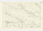
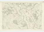
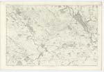
| KEIR | Keir Keir Keir Keir Keir Keir Kire |
Chalmers' Caledonia The Stat: Acc: [Statistical Account] of Dumfries Fullerton's Gazetteer Dr. [Doctor] Singer's Survey Johnstone's Co. [County] Map Valuation Roll of Parish Pennant's Tour |
030; 031; 040 | [Situation] In the centre of Nithsdale. The name of this Parish is supposed to be derived from the old British word "Caer "a Fort," and in support of which, a Spot near Nether Keir can still be pointed as Site of an Ancient Tower or Fort. The appellation Caer has assumed the form of Keir in many of the names of places in Scotland. Another - and somewhat fanciful conjecture is, that the name is derived from the particular colour of the Soil - "Keir signifying "black or brown". Keir Parish is situated in the centre of the district called Nithsdale, forming a slender oblong, stretching from Northwest to Southwest. Bounded on the North by Penpont North-East by Closeburn and Kirkmahoe, South by Dunscore, South-West by Glencairn, And North West by Tynron - its greatest length is 6 1/2 Miles and its greatest breadth 2 1/2 Miles; but as its average breadth is scarcely 2 Miles, its superficial [Continued on page 2] |
Continued entries/extra info
[Page] 1Transcribers who have contributed to this page.
CorrieBuidhe- Moderator, georgelaidlaw
Location information for this page.