OS1/10/19/13


| List of names as written | Various modes of spelling | Authorities for spelling | Situation | Description remarks |
|---|---|---|---|---|
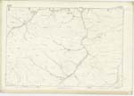
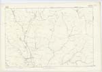
| MITCHELL HILL | Mitchell Hill Mitchell Hill |
Archibald Glendinning Farmer Glendearg James Glendinning Farmer Over Cassock |
011 | [Situation] About 1/2 Mile S.W. [South West] of Blaeberry Edge A large hill the surface of which is rough pasture, heathy pasture, and scattered rocks; on the farm of Over Cassock, situated between Glendearg Burn, and Little Cauldron Burn, and extending north from The Kaim till it reaches the County Boundary, a little to the west of Glendearg Steps. |
| LITTLE CAULDRON BURN | Little Cauldron Burn Little Cauldron Burn |
Archibald Glendinning Farmer Glendearg James Glendinning Farmer Over Cassock |
011 | [Situation] About 25 Chains S.W. [South West] of Mitchell Hill A considerable stream having its source near a Trigl. [Trigonometrical] Station on the highest point of The Kipps, and flowing from that in a southerly direction till it joins Muckle Cauldron Burn, and assumes the name, Strongcleugh Burn |
| THE KAIM | The Kaim The Kaim |
Archibald Glendinning Farmer Glendearg James Glendinning Farmer Over Cassock |
011; 018 | [Situation] About 30 Chains South of Mitchell Hill A long undulating Ridge the surface of which is covered with rough pasture situated between the Southern base of Mitchell Hill and Strongcleugh Burn. |
Continued entries/extra info
[Page] 13Parish of Eskdalemuir
Sheet 11 No. 13. Trace 4
The Kaim [note] - Kaim. A low ridge
Is used to denote the crest of a hill or those pinnacles which
resembles a Cock's Comb. &c. Jamieson's Dictionary
Transcribers who have contributed to this page.
CorrieBuidhe- Moderator, gengirl44
Location information for this page.