OS1/10/8/1


| List of names as written | Various modes of spelling | Authorities for spelling | Situation | Description remarks |
|---|---|---|---|---|
| DALTON [parish] | Dalton Dalton Dalton |
Walkers' Map of Scotland Crawford's Map of Dumfriesshire Blackwood's Map of Dumfriesshire |
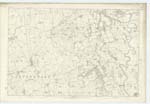
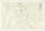
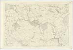
050; 056; 057 | [Situation] Towards S. Wn. [South Western] extremity of the County of Dumfries The Name of this Parish is compounded of Anglo-Saxon Dal and Dun - the Fort in the Dale. Accordingly the remains of an ancient fort in the immediate vicinity of Dalton village is pointed out as descriptive thereof. The Parish of Dalton is bounded on the North by that of Lochmaben, on the East by Dryfesdale, St Mungo and Cummertrees on the South by Ruthwell and on the West by Mouswald and Lochmaben. The Boundaries on the North are centre of Rangegill Burn, Top of Bank, Track of old Bank, Top of Bank undefined Top of Bank Track of Old Bank undefined Top of Bank undefined Centre of Wall undefined Centre of Wall undefined Top of Bank Centre of Wall Paling Top of Bank undefined Top of Bank Track of old Bank undefined Top of Bank Root of Hedge centre of Bank undefined Root of Hedge undefined Root of Hedge undefined and Paling - on the East Centre of River Annan Centre of Gillhall Burn Centre of Bank Root of Hedge Top of Bank undefined centre of Bank Root of Hedge Centre of Bank Centre of wall undefined - on the South Centre of wall, undefined, centre of wall centre of Hardgrave Burn undefined Root of Hedge Centre of drain Centre of wall Root of Hedge centre of Bank and on the West centre of Bank Root of Hedge Centre of Bank centre of Old drain Root of Hedge undefined centre of Bank Centre of wall Centre of Bank Root of Hedge centre of wall undefined and centre of wall. There is no detached part of Dalton within the Boundaries of another Parish nor within its limits a detached portion of another Parish. Its Shape would approach to that of a square with a pojection jutting out for about 2 miles towards the North-west were it not for a deep indentation near the middle of the Northern Boundary. Its greatest length is 6 miles and average breadth a little over 2 1/2 miles. Its Area as per Statistics is 6753 Acres of which 600 are uncultivated - 517 wood and 5636 Arable and pasture The surface is flat except towards the North-West where it rises to a height of 500 feet. On the uplands the Soil is Sand and gravel along the banks of the Annan it is a light alluvial loam between which and centre of Parish it is chiefly meadow or reclaimed moss, towards the South-East meadow or reclaimed bog and in some parts of the interior it is a cold clay. The soil on a whole is not in a good state of cultivation neither are the lands so well enclosed as in the majority of other Parishes in this County. Farm houses and Steadings are for the most part in bad repair and have but small accommodation. The average rent of land is 13S. p, acre [thirteen shillings [£0.13.0] per acre]. This Parish is watered on the East by the Annan and many inland streams. The highest elevations are Almagill Hill and Holmain Moor towards the North-West which attain an equal altitude of about 500 feet. Though no line of Railway passes through this Parish it is nevertheless conveniently situate between those of the Caledonian in adjoining Parish of Dryfesdale and Glasgow & South-western in Ruthwell which nearly touches it towards the south extremity. The Turnpike Road from Carlisle to Portpatrick runs through the South end of this Parish for a distance of 2 1/2 miles. There is no Manufacture carried on neither has any mineral been discovered Also in N En [North Eastern] district the Turnpike road from Lochmaben to Annan runs from North to south for about 3 miles. Lime and Sandstone quarries have been opened however in several parts but which are now disused or shut up. The only village is Dalton situate near the centre of Parish 10 1/2 miles from Dumfries and 6 1/2 from Annan, which consists of a single Street of one storey houses running from North east to South west measuring about 12 chains long and which is altogether rural and unimportant. In it is the Parish Church - a diminutive structure with a very small belfry - erected 1704 for the accommodation of 300 Sitters - Stipend £181. 12/ 11d [£181.12.11] Patron Carruthers of Holmains - a Parish School recently erected and very commodious - presenting a somewhat attractive appearance on entering the village from the South - Salary £34. 4/3. [£34.4.3] with £20 fees - also an Infant School supported partly by subscription and donations from Parish Proprietors - and one public house. About 1 1/2 [Continued on page 2] |
Continued entries/extra info
[page] 1Parish of Dalton -- Co. [County] Dumfries
Transcribers who have contributed to this page.
Moira L- Moderator, gengirl44
Location information for this page.