OS1/10/7/1


| List of names as written | Various modes of spelling | Authorities for spelling | Situation | Description remarks |
|---|---|---|---|---|
| CUMMERTREES [parish] | Cummertrees | WalKers' Map of Scotland Crawford's Map of Dumfries-shire Johnston's Map of Dumfries-shire |
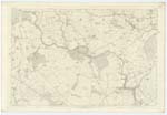
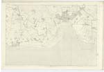
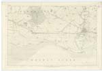
057; 061; 062; 066 | [Situation] At the Sn [Southern] extremity of the County of Dumfries The Name of this Parish was originally spelt Cumbertrees as appears by Some Charter-deeds of the 12th Century, and which Name Chalmers in his Caledonia derives from British Cum - ber - tre, - the hamlet at the end of the short valley said to be descriptive of An Ancient village which stood at a short distance South of the present Parish Church, the exact Site of which cannot now be shewn. The Parish of Cummertrees is bounded on the North partly by those of Dalton St. Mungo and Hoddom, on the East by Annan, on the South by the Solway Firth and in the West by Ruthwell and Dalton. There is no detached part of the Parish situate within the boundaries of anoth [another] Parish nor is there within the limits here assigned to it a detached portion of any other Parish. Its form is very irregular at the East, it measures about 7 miles in extreme length and about 4 miles in extrem [extreme] breadth" [Continued on page 2] |
Continued entries/extra info
[page] 1Parish of Cummertrees -- County of Dumfries.
Transcriber's notes
Words lost in fold of page.Transcribers who have contributed to this page.
Moira L- Moderator, SR1960
Location information for this page.