OS1/5/40/1


| List of names as written | Various modes of spelling | Authorities for spelling | Situation | Description remarks |
|---|---|---|---|---|
| WESTRUTHER [Parish] | Westruther (Parish) | New Statistical Account of Berwickshire Map of Berwickshire Chalmer's Caledonia |
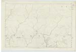
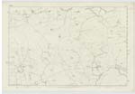
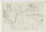
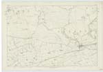
014 ; 015 ; 020 ; 021 | A parish, lying debateably between Lauderdale, & Lammermoor, Berwickshire. It is bounded on the North by "Cranshaws" on the East by Longformacus & Greenlaw, on the South by Gordon & Legerwood; Its length, from north to South is 6 Miles, iits breadth Varies from 3 to 5½ Miles; and its superficial extent is about 22½ Square Miles. The Northern district, comprising between a third and a half of the whole area, comes Slowly down from an elevation of about 1260 feet above Sea-level, & is a lumpish & rolling mass of bleak, barren, cheerless upland, but commands brilliant and far stretching prospects of Merse & Teviotdale [Continued on Page 2] |
Continued entries/extra info
[page] 1Parish of Westruther -- W Beatty
Transcribers who have contributed to this page.
Moira L- Moderator, GreenflyNZ
Location information for this page.