OS1/3/22/1


| List of names as written | Various modes of spelling | Authorities for spelling | Situation | Description remarks |
|---|---|---|---|---|
| DALRYMPLE [parish] | Dalrymple Dalrymple Dalrymple Dalrymple |
Statistical Account. Paterson's History of Ayrshire. Johnstons county Map. County Voters list. |
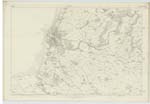
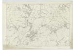
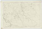
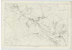
033 ; 039 ; 040 ; 046 | "The name of this parish, written in old documents Dalrimpill, is derived apparently from the Celtic Dail-a'-chruim-puill, signifying the dale of the crooked pool, which even at this day, is accurately descriptive of the valley or dale where stand the church and village of Dalrymple, & it would be still more so at the time the name was given. The Doon which interseccts the level, turns & bends considerably; but anciently it was much more crooked. The outline of the old course of the river , from below Nether Skeldon till it reaches the village is still traceable - describing almost the figure S. The extent of the parish from east to west, is about seven miles; its breadth, three; & it contains about twelve square miles. It is bounded on the north and east by the parishes of Ayr, Coylton & Dalmellington; & on the south & west by the River Doon, which separates it from the parishes of Straiton, Kirkmichael, & Maybole. With the exception of the valley, where the village & church are situated, none of the rest of the parish can be termed level, for the surface abounds with numerous rising grounds, or little round hills, from the most of which are seen the islands of Bute and Arran, the peninsula of Cantyre, Ailsa Craig, & the 'lofty [continued on page 2] |
Continued entries/extra info
[Page] 1Parish of Dalrymple
Transcribers who have contributed to this page.
Trondragirl- Moderator, John Dunlop
Location information for this page.