OS1/3/18/1


| List of names as written | Various modes of spelling | Authorities for spelling | Situation | Description remarks |
|---|---|---|---|---|
| CRAIGIE [parish] | Craigie Craigie Craigie Craigie |
Statistical Account Paterson's History of Ayrshire Johnston's County Map County Voters List. |
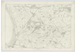
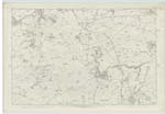
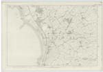
022 ; 023 ; 027 | The Parish is bounded on the north by Riccarton & Galston, on the East, by Mauchline; on the south by Tarbolton & on the West by Monkton and Symington. Craigie Parish and that of Riccarton were formerly united but were disjoined in 1647. The hills, near the church, with the exceptions of a craggy rock jutting out here and there are covered with verdure to the very Summit & although comparitively low, being only about 500 feet above the level of the Sea, the view from them is extensive and beautiful. The Parish contains a part of the Suppressed parish of Barnweill, the greater part of the stiped of Barnweill being transferred to the Support of the minister of Stair. The parish is, in a direct line, above Seven miles long and one and a half broad on an average. *** This Parish is entirely agricultural. There are three limestone quarries & there is one tile-work, lately erected, which produces good tiles and is of great advantage to the farmers. The parish contains coal of different kinds both what is termed dross, and cannel coal. The coal has been wrought in several places and at different" [Continued] |
Continued entries/extra info
[Page] 1Parish of Craigie
Transcribers who have contributed to this page.
Chr1smac -Moderator, DANIALSAN
Location information for this page.