OS1/1/27/12


| List of names as written | Various modes of spelling | Authorities for spelling | Situation | Description remarks |
|---|---|---|---|---|
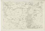
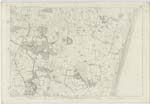
| RIVER DON | Don (The) Don River River Don River River River Don |
Fullarton's Gazetteer of Scotland Johnstone's C [County] Map New Statistical Account Donside Guide Book Mr. Alexander Watt |
065; 066 | [Continued from page 11] as the locks at its mouth confine it to a narrow channel, and give it there a gloomy aspect, the idea of its flowing rapidity through a rugged and mountainous country, where no space is left for forming even a commodious road along it banks, is at first induced; but after passing upwards for about a mile beyond the rocky chasm, where was built the spacious, stately and attractive Gothic arch, constituting the celebrated Brig O' Balgownie, and up to whose locality alone the Don is navigable even for small craft, the hills recede so far from the river, as to form spacious haughs or level valleys on either side, through which it winds in a slow majestic course. Nor is the prospect here uniform, but agreeably diversified. The hills above Inverury approach close to the river, which seems to have forced its way with difficulty through them; but all at once it opens into another spacious plain, from which the hills recede on either hand to a great distance, and then close again; and, after another temporary confinement among rocks and hills and woods, the river once more waters another plain of great extent. Such is the general character of the Don, - nowhere rapid, but in general flowing through level fields so little elevated above its usual surface, that, when violent rain falls, it bursts its bounds at once, and covers a great extent of country which then appears to be an immense body of water interspersed with islands, houses, trees, and other rural objects. Too often on these occasions it commits extensive and calamitous depredations, - sweeping off whole fields of corn and leaving nothing behind but want and desolation. *** A great part of the haugh - land is now protected by embankment on the lands of Fintray and Wester Fintray extending to upwards of 6000 ells in length, and protecting from 200 to 300 Scotch acres of very fine rich land, from the river floods. Similar embankments have been made for the protection of the haugh - lands in most other parts of the river's course." Fullarton's Gazetteer of Scotland |
Continued entries/extra info
[Page] 12Aberdeenshire -- Parish of Dyce
Transcribers who have contributed to this page.
CorrieBuidhe- Moderator, Liz Dow
Location information for this page.