OS1/35/87/22


| List of names as written | Various modes of spelling | Authorities for spelling | Situation | Description remarks |
|---|---|---|---|---|
| SLEWDOWN | Slew Down Slew Down Slew Down Slewdown Slewdown |
Hugh Hedger Peter McGaw John Bone William Todd Drummore John McCulloch Cardryne |
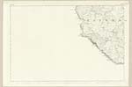
035 | [situation] 1¼ miles NW. by W [North West by West] of Mull (farm house) A large hill on the lands of Cardrain the soil of which is chiefly arable land with the exception of a small portion of heathy pasture on its Summit.- |
| CARDRAIN | Cardrain Cardrain Cardrain Kirkdrain Cardrain Cardrain Cardrain |
John McGaw John Bone Hugh Hedger William Todd Proprietor's Rent Roll Rl. Engrs. [Royal Engineers] Map 1819 Ainslie's Map 1782 Old Map of Scotland |
036 | [situation] About one mile west of Mull (farm house) A tract of land formerly one farm but is now divided into several small holdings or farms respectively occupied by John McCulloch John McGaw & John Bone The property of the Earl of Stair, the portion occupied by John Bone are sometimes called Pulinkum but the above mens Address are all Cardrain. This tract of land was formerly the church lands hence the name. -The first protestant [Minister] had his manse on this land, the church was at the Mull of Galloway - |
Continued entries/extra info
[page] 22Parish of Kirkmaiden
Form 136
Page 101- Slew Down
94- Cardrain
"See note on KirKdryne or Kirkdrain
in page 20
Transcribers who have contributed to this page.
Chr1smac -Moderator, Brenda Pollock
Location information for this page.