OS1/35/66/9


| List of names as written | Various modes of spelling | Authorities for spelling | Situation | Description remarks |
|---|---|---|---|---|
| DAM HILL | Dam Hill Dam Hill Dam Hill Dam Hill |
Colin Christison J. Cowan John McGuffie George McHaffie Esqr. |
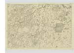
025 | [Situation] 1/2 mile N. E. [North east] of Bell's Moor Plantation. A tolerable large hill the Soil of which is arable. On part of this hill is a plantation. |
| BLAIRMAKIN MUIR | Blairmakin Muir Blairmakine Muir Blairmakin Blairmakine Blairmakin Muir |
Colin Christison Title deeds of property Ainslies Map of 1782 Royal Engrs. [Engineers] Map. George McHaffie Esqr. |
025 | [Situation] On the S.E. [South East] side of Barnbarroch Ornamental Ground. A Small tract of Moor Consisting of about 20 acres. It takes its name from a farm Called Blairmakine. - |
| DRUMJARGON HILL | Drumjargon Drumjargon Drumjargan Drumjargon Hill |
Colin Christison J. Cowan Royal Engrs. [Engineers] Map. George McHaffie Esqr. |
025 | [Situation] 1/4 mile East of Bell's Moor Plantation. A moderate Sized hill on the farm of Drumjargon. It is of Slight elevation, the surface is arable land. |
Continued entries/extra info
Parish of Kirkinner -- [Page] 9Form 136
Page 41-- Dam Hill
28 -- Blairmakin Muir
43-- Drumjargon
[Note] "Blar" a plain, a field.-
na ... of
"Cìnn" Heads etc.
literally. The Field of Heads.
Transcribers who have contributed to this page.
Chr1smac -Moderator, Muriel Rousay
Location information for this page.
Linked mapsheets.