OS1/35/27/13


| List of names as written | Various modes of spelling | Authorities for spelling | Situation | Description remarks |
|---|---|---|---|---|
| WOODHILL | Woodhill Woodhill . Woodhill Wood-hill . Woodhill . . Woodhill |
Mr Samuel Heron Mr Alexander Hunter Ainslie's map 1782 Old Ordnance map of Wigtownshire Map of Marquis of Bute's Property 1792 George McHaffie Esqr. |
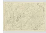
012 | [Situation] Close to & South of Loch Ronald. The remains of an Old Stone Building situated at the south end of Lochronald and at one time was the residence of the Laird of Ronald. |
| BLAIRNAGOBBER | Blairnagobber Hill Blairnagobber Hill Blairnagobber Hill |
John Dougan William Stroyan James McCaa |
012 | [Situation] 1 1/2 miles S.E [South East] of Loch Ronald. A small hill on the farm of Barmore, on which is a Trigl. [Trigonometrical] Station called by the Trig [Trigonometrical] Party Barnagrubber. |
| CROTTEAGH HILL | Cruitheagh Hill . Crotyeuck . . Crotteagh Hill . Croteagh Hill |
Mr William McKenna Map of Marquis of Bute's property 1792 George McHaffie Esqr. James McCaa |
012 | [Situation] 1/3 mile SE [South East] of Loch Ronald. A small cultivated hill on the farm of Low Mains, on which is a Trigl. [Trigonometrical] Station. |
Continued entries/extra info
[Page] 13[Plan] 12C -- Parish of Kirkcowan
Form 136 Page 43 Woodhill
48 Blairnagobber
48 Crotteagh Hill
Transcribers who have contributed to this page.
Chr1smac -Moderator, JCB
Location information for this page.
Linked mapsheets.