OS1/33/18/84


| List of names as written | Various modes of spelling | Authorities for spelling | Situation | Description remarks |
|---|---|---|---|---|
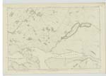
| AN GRIANAN | An Grianan | Rev. [Reverend] J.M. Joass, Golspie William McLeod, Unapool John McMichael, Glendhu |
050 | Applies to a top or Knoll Situate above Leitir Mhòr about 3/4 miles N.E. [North East] from Kylesku Ferry. Sig:- [Signification] "Sunny Spot." |
| LEITIR MHÒR | Leitir Mhòr | Rev. [Reverend] J.M. Joass, Golspie William McLeod, Unapool John McMichael, Glendhu |
050 | Applies to a long stretch of hillside on the N. [North] Side of Loch Glendhu, extending from Kylestrome about 1 1/2 miles E. [East] to near Maldie. Sig:- [Signification] "Large Hillside". |
| LOCH GLENDHU | Loch Glendhu | Rev. [Reverend] J.M. Joass, Golspie William McLeod, Unapool John McMichael, Glendhu |
050 | Applies to a narrow arm of the Sea extending E. [East] about 3 1/2 miles from Kylesku Ferry. It is celebrated for herring-fishing. It forms the Bdy. [Boundary] between the parishes of Assynt & Edderachilles for a short distance E. [East] of Kylesku Ferry. |
Continued entries/extra info
[Page] 84Sheet 50 -- Parish of Edderachillis -- County Sutherland.
[Signed]
P. Dougherty
2nd. Corpl. R.E.
[2nd. Corporal Royal Engineers]
Transcribers who have contributed to this page.
KBMW- Moderator
Location information for this page.
Linked mapsheets.