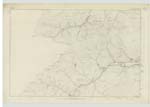
OS1/30/3/49


| List of names as written | Various modes of spelling | Authorities for spelling | Situation | Description remarks |
|---|---|---|---|---|
| Pikestone Rig | Pikestone Rig Pikestone Rig Pikestone Rig Pikestone Rig |
William Laidlaw Thirlststane Hope Alexander Laidlaw James Dalglish, CraigHo. [CraigHope] County Map |
017 | A long range of Hills. Overlooking the Loch of the Lowes and from which there is a Commanding view of a portion of Dumfries Shire - Situated about 1 mile west Of the Lough and 5 miles North of Ettrick Kirk. |
| Easter Cleuch | Easter Cleugh Easter Cleuch Easter Cleuch |
William Laidlaw A Laidlaw James Dalglish |
017 | A ravine through which runs a rough stream Rising in a large Moss about ¼ of a mile west of Cowan's Croft flowing into a stream called Contercleugh. |
| Mid Cleuch | Mid Cleuch Mid Cleuch Mid Cleuch |
William Laidlaw A Laidlaw James Dalglish |
017 | A ravine through which runs a small stream rising out of Plouer Hash flowing N. [North] West into Contercleugh. |
| Wester Cleuch | Wester Cleuch Wester Cleuch Wester Cleuch |
William Laidlaw A Laidlaw James Dalglish |
017 | A ravine through which runs a small stream rising a little to the North of Rig Head. Flowing into Contercleugh in a Westerly direction. |
Continued entries/extra info
[Page] 49Co. [County] of Selkirk -- Parish of Ettrick -- Plan 17. Trace 3
Described by Corpl. [Corporal] Leslie R. E. [Royal Engineers]
Transcribers who have contributed to this page.
Trondragirl- Moderator, M.Ogilvie
Location information for this page.
Linked mapsheets.