OS1/29/41/1


| List of names as written | Various modes of spelling | Authorities for spelling | Situation | Description remarks |
|---|---|---|---|---|
| WILTON [parish] | Wilton Wilton Wilton |
Crawford's Map of Scotland Johnston's Map of Roxburghshire New Statl [Statistical] Account of Roxburghshire |
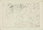
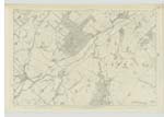
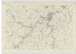
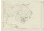
019; 020; 025 | [Situation] at the West side of Roxburghshire. The name of this Parish in the modern abbreviated orthography of Wiltown. The origin of the name has not been ascertained, but in ancient documents Walltown and Willis-town are the designation given to this Parish. The Parish of Wilton is bounded on the North by part of SelKirkshire and Minto Ph [Parish], on the East by Minto, Cavers and Hawick, on the South by Hawick and on the West by Roberton and Ashkirk. There is no part of it within the boundaries of another Parish, nor is there within the limits above assigned to it a detached portion of any other Parish. Its figure is that of a parallelogram extending North-east and South-west. In extreme length and breadth it is respectively nearly 5 1/2 miles. Its entire area has been computed at 8,820 acres of which about 2/3 may be arable, 100 wood and the remainder for the most part, good hill pasture. The interior is hilly, the heights however - which are broad based and of gentle acclivity admit of Cultivation but towards the S.wn. [South western] district they are left in pasture. The River Teviot the principal Stream entering the Parish at its Southern extremity - traces the En. [Eastern] boundary and at its point of ingress receives Borthwick Water also a considerable Stream which traces for the most part the Sn [Southern] Boundary Numerous [Continued on page 2] |
Continued entries/extra info
[Page] 1Parish of Wilton -- County of Roxburgh
Transcribers who have contributed to this page.
Trondragirl- Moderator, Brenda Pollock
Location information for this page.
Linked mapsheets.