OS1/29/40/1


| List of names as written | Various modes of spelling | Authorities for spelling | Situation | Description remarks |
|---|---|---|---|---|
| TEVIOTHEAD | Teviothead | Oliver & Boyd's Edinburgh Almanac. Plan of proposed Parish (1849) |
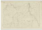
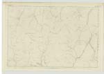
024; 025; 031; 032; 036; 037; 038 | [situation] At the South West end of the County of Roxburgh. The name of this Parish originates with the River Teviot which - taking its rise at the Swn. [Southwestern] direction drains the entire central division of the Parish. The Parish of Teviothead is bounded on the North by those of Roberton and Hawick, on the East by Hawick, Kirkton and Cavers, on the South partly by Castleton and Dumfries-shire and on the West by Dumfries-shire and Roberton Parish. It was erected into a Parish from disjoined portions of Hawick and Cavers by Summons of disjunction and erection at the instance of the Duke of Buccleuch against the heritors of these Parishes dated 1849. It measures in length from N.E. [North East] to S.W. [South West] about 9½ miles and in breadth from West to East 7 miles and contains an area of about 31,560 Impl. [Imperial] Acres. The Southern division is nearly all in hill-pasture - the northern district exhibiting many striking varieties of hill and dale well sub-divided enclosures and excellent pasturage. The greatest elevations are PiKethaw Hill, Triep Hill and Tudhope Hill on the Southern boundary common to Dumfriesshire. The principal Stream River Teviot rising [continued on page 2] |
Continued entries/extra info
[page] 1Parish of Teviothead -- County of Roxburgh
[note] No detached part of Teviothead is situate within another Ph. [Parish] and there are not within the boundaries of the same a detd. [detached] portion of any other ph. [parish].
Transcribers who have contributed to this page.
Bizzy- Moderator, Brenda Pollock
Location information for this page.
Linked mapsheets.