OS1/29/31/152


| List of names as written | Various modes of spelling | Authorities for spelling | Situation | Description remarks |
|---|---|---|---|---|
| BERRYSTELL HOPE | Berrystell Hope Berrystell Hope Berrystell Hope |
George Douglass Steward Upper Hindhope James Turnbull Shepherd Nether Hindhope John Robson Shepherd Nether Hindhope |
035 | [Situation] W. [West] from Brownhart Law. A hollow the surface of which is mountain grass land it extends from Berrystell Fell to Hindhope Burn there is a small stream flowing through it |
| HINDHOPE BURN | Hindhope Burn Hindhope Burn Hindhope Burn |
George Douglass Steward Upper Hindhope James Turnbull Shepherd John Robson Shepherd |
028.14 | [Situation] Between Whiteside Hill and Berrystell Fell. A burn having its source from Chew Edge and flows into Kale Water near Nether Hindhope |
| BERRYSTELL FELL | Berrystell Fell Berrystell Fell Berrystell Fell |
George Douglass Steward James Turnbull Shepherd John Robson Shepherd |
035 | [Situation] S.W. [South West] from Brownhart Law. A high hill the surface of which is mountain grass land situated on the farm of Upper Hindhope and is the property of the Duke of Roxburgh |
Continued entries/extra info
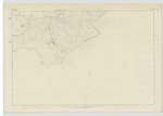
[Page] 152Parish of Oxnam -- 6 inch -- Sheet 35 Trace 2
[Signed] Thomas Ratcliffe ca [civilian assistant]
Transcribers who have contributed to this page.
Trondragirl- Moderator, Douglas Montgomery
Location information for this page.
Linked mapsheets.