OS1/29/7/71


| List of names as written | Various modes of spelling | Authorities for spelling | Situation | Description remarks |
|---|---|---|---|---|
| TINNIS BURN | Tinnis Burn Tinnis Burn Tinnis Burn |
Thomas Mason, Farmer, Blackburn James Nicoll, New Castleton James Elliot, Middleholm |
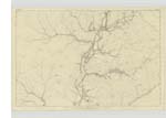
044; 045; 048 | [Situation] From the East of watch Craig S. E. [South East] to Liddel Water. A large stream having its source about twenty chains east of Watch Craig, and flowing in a southerly direction, falls into Liddel Water. |
| TINNIS BRIDGE | Tinnis Bridge Tinnis Bridge Tinnis Bridge |
Thomas Mason, Farmer, Blackburn James Nicoll, New Castleton James Elliot, Middleholm |
045 | [Situation] Over Tinnis Burn. A stone bridge of one arch over Tinnis Burn, on the road heading from New Castleton, to Langholm. Upheld by the Parish Authorities |
| BURROWSTOWN MOSS | Burrowstown Moss Burrowstown Moss |
James Elliot. Property Documents |
044 | [Situation] On the Boundary between Roxburgh and Dumfriesshire A large patch of moss on the farms of Flatt & Perterburn; the boundary seperating the Counties of Roxburgh & Dumfries, passes over it. |
| LOCH KNOWE | Loch Knowe Loch Knowe Loch Knowe |
James Elliot. Property Documents Johnston's County Map |
045 | [Situation] On the Boundary between Dumfries and Roxburghshire A small knowe, over the highest point of which, the boundary separating the Counties of Roxburgh and Dumfries, passes. |
Continued entries/extra info
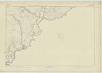
[Page] 71Parish of Castleton -- Sheet 44 - No. 12 -- Trace 1
[signed] P McHugh Lce. Cpl. R.E. [Lance Corporal Royal Engineers]
Transcribers who have contributed to this page.
Moira L- Moderator, Douglas Montgomery
Location information for this page.