OS1/25/20/5


| List of names as written | Various modes of spelling | Authorities for spelling | Situation | Description remarks |
|---|---|---|---|---|
| CULROSS [parish] | Culross Culross Culross Culross Culross Culross Culross Culross |
Sheriff's List of Meresmen New Stat. Acct. [Statistical Account] Old Stat. Acct. [Statistical Account] Fullarton's Gazetteer Oliver & Boyd's Almanack Johnston's Co. [County] map Stobie's Co. [County] map Valn. [Valuation] Roll 1857-8 |
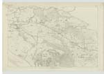
140; 143 | [Situation] On the north Side of the Firth of Forth A parish belonging to Perthshire though locally disjointed from it by the intervention of Clackmannanshire and politically conjoined withthe Shires of Clackmannan and Kinross. It forms nearly a square of 4 miles containing 8,145 Scots acres or thereabouts and is bounded on the west by Tulliallan; on the north-west by Clackmannan on the north by Saline; on the east by Torryburn; and on the south by the Firth of Forth. The barony of Kincardine was disjoined from this parish in 1672 and united with Tulliallan. The surface is level if we exempt the abrupt ascent from the shore. The northern part of the parish consists of moorland which is planted with wood: the southern is fertile and particularly that part of it which intersected by the Bluther which uniting with another streamlet called the Grange falls into the sea at Newmills Bridge where it forms the eastern boundary of the parish. It abounds with freestone, ironstone, ochre and a species clay highly valued by potters and by glass manufacturers Coal the chief mineral product was wrought here at a very remote period by the men |
Continued entries/extra info
[Page] 5Parish of Culross
Transcribers who have contributed to this page.
Bizzy- Moderator, Trondragirl- Moderator, John Burt
Location information for this page.