OS1/24/40/40


| List of names as written | Various modes of spelling | Authorities for spelling | Situation | Description remarks |
|---|---|---|---|---|
| HAMILTON'S WELL | Hamiltons Well | Andrew Wedderston Shepherd Traquair Knowe Archibald Reid Shepherd Damhead |
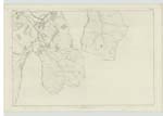
018 | [Situation] On the left bank of Glengaber or Fingland Burn. A spring on the eastern slope of Damhead Rig |
| MINCHMUIR | Minch Muir Minch Muir Minch Moor Minch Moor Minch Moore Minch Muir |
[Revd. [Reverend] James Campbell Andrew Inglis, Schoolmaster Armstrongs Map Chalmers Caledonia Ponts Map 1608 Pennecuiks descrip. [description] |
018 | [Situation] On the S.E. [South East] A high hill on the S.E. [South East] confines of the Parish of Traquair traversed by the old road from Traquair to Selkirk. - |
| WHITE HOPE | White Hope | Thomsons Atlas (Peebles) Andrew Wedderston Shepherd Traquair Knowe |
018 | [Situation] About a Mile South from Minch Muir. A hill from whose northern slope the Tributaries of Glengaber & Fingland Burn have their source. - |
Continued entries/extra info
[Page] 40Traquair Parish
Sheets 18-10 & 11
Transcribers who have contributed to this page.
DANIALSAN, JOANMUIR
Location information for this page.
Linked mapsheets.