OS1/24/18/3


| List of names as written | Various modes of spelling | Authorities for spelling | Situation | Description remarks |
|---|---|---|---|---|
| KIRKURD | Kirkurd Kirkurd Kirkurd Kirkurd Kirkurd Kirkurd Kirkurd Kirkurd |
Sheriff's List of Parishes Chalmers Caledonia Old Stat Acct [Statistical Account] V [volume] 10 Page 177 Johnston's County Map Oliver & Boyds Almanack Fullarton's Gazetteer New Stat Acct.[Statistical Account] Origines Parochiales Scotiæ |
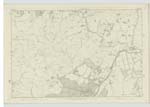
007 ; 008 ; 011 ; 012 | [Situation] In the Western Portion of the County of Peebles A Parish in the County of Peebles bounded on the North by Linton, on the N E [North East] by Newlands, on the East by Stobo; on the South by Stobo and Broughton, on the South West by Skirling and the West by the County of Lanark -- It is about 5½ Miles in length from east to West And from 3 to 4 miles in breaath and comprehending about 6,620 English Acres, the Road from Edinburgh to Moffat passes through it. Nearly one half of the Parish is Arable lying rather high but beautifully diversified by hill and dale it gradually rises from the Tarth Water to its Southern boundary where it gains an elevation of upwards of 2000 feet, the highest part of the Southern Range is Called Hells Cleugh -- Near Castlecraig is a Sulpherous Spring and in the Demesne of Castlecraig are two Moats or Artificial Mounds Supposed to be Seats of Justice in Feudal Times, to the East and West of these Mounds are two circular fortifications called The Rings and The Chesters. There are no detached portions of other Parishes within this Parish or [Continued on page 4] |
Continued entries/extra info
[page] 3Parish of Kirkurd
Transcribers who have contributed to this page.
Moira L- Moderator, P Wills
Location information for this page.