OS1/24/6/54


| List of names as written | Various modes of spelling | Authorities for spelling | Situation | Description remarks |
|---|---|---|---|---|
| THE SCRAPE | The Scrape The Scrape The Scrape Scrape Scrape |
J Ingram Bellspool J Dodds Wester Dalwick William Paterson Par [Parish] School Johnston's Co [County] Map Armstrong's Co [County] Map New Stat Acct [Statistical Account] |
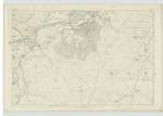
016 | [Situation] Eastern Boundr [Boundary] of Parish of Drummelzier A consideralbe eminence of a somewhat Conical Shape over which the Ph [Parish] Boundary passes betweeen Drummelzier and Mannor. It is Situated on the Farm of Drummelzier Haugh and Wester Dalwick and its surface is Covered with Heathy pasture. |
| SCRAPE BURN | Scrape Burn Scrape Burn Scrape Burn |
J Ingram J Dodds Farmer William Paterson |
016 | [Situation] About 1/2 Mile West from The Scrape A Stream which rises out of Broad Moss at the South side of The Scrape, and flows in a Westerly direction to where it joins the Drummelzier Burn. |
Continued entries/extra info
[Page] 54Parish of Drummelzier -- Sheet 16 No 11 Trace 2
Transcribers who have contributed to this page.
Bizzy- Moderator, P Wills
Location information for this page.
Linked mapsheets.