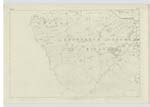
OS1/24/3/34


| List of names as written | Various modes of spelling | Authorities for spelling | Situation | Description remarks |
|---|---|---|---|---|
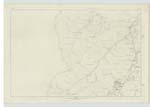
| CHAPELGILL HILL | Chapelgill Hill Chapelgill Hill Chapelgill Hill Chapelgill Hill Chapelgill Hill Chaplegill Hill |
Alexander Tod William Lithgow James Watson Adam White Johnston's Co. [County] Map Armstrong's Co. [County] Map |
015 ; 019 | [Situation] About ¾ of a Mile S [South] of Cardon Hill A Considerable Eminence at the West side of Cardon Hill; and North side of the Holms Water. It is of Consider [Considerable] Elevation; the surface is Rough Pasture; and its summit Comm [Commanding] many Extensive Views. It is of a Conical shape, and slopes Gently Southwards to the Holms Water, and Eastward to Glenhigton Burn, - which seperates it from Cardon Hill. |
| CARDON BURN | Cardon Burn Cardon Burn |
Alexander Tod William Lithgow |
015 | [Situation] Flows about ¼ of a Mile S.E [South East] of Cardon Hill A small stream formed from Strings & surface Water at the W [West] side of Cardon Hill, and flowing Southwards through a Steep Valley into the Holms Water. |
Continued entries/extra info
[page] 34Parish of Glenholm
Sheet 15 No. 14 -- Trace 1
Transcriber's notes
Words lost in fold of page.Transcribers who have contributed to this page.
Moira L- Moderator, P Wills
Location information for this page.