OS1/23/25/1


| List of names as written | Various modes of spelling | Authorities for spelling | Situation | Description remarks |
|---|---|---|---|---|
| WALLS | Walls | Johnstons Map of Orkney Peaces Map of Orkney Andersons Guide to the Highlands. Philip's County Atlas of Scotland Oliver & Boyds Edinburgh Almanac Peaces Orkney Directory Orkney & Shetland Guide & Directory Star A/C of Scotland Imp Gazetteer of Scotland John A Bruce Esq Sheriff Clerk Orkney, |
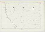
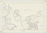
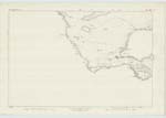
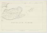
118; 119; 122; 123 | Walls. A parish Containing the post Office Station Longhope, in the South Isles district of Orkney. It Consists of the southern part or considerably more than the half, of the island of Hoy. But the part of it to the south of Longhope Bay being very deeply peninsulated by that bay, and at times completely insulated by an influx of spring tides to the head of that bay from the opposite Coast, Constitutes South Walls. It is bounded on the South by the Pentland Firth on the North by the Parish of Hoy, on the west by the Atlantic ocean & on the east by Cantick Sound, Smitha Sound, Long Hope & Guther Sound. There is no detached part of this parish locally Situated within the boundary of any other parish nor is there any detached part of any other locally situated within the boundary of this one. It contains about 22091 Statute Acres |
Continued entries/extra info
[page] 1Parish of Walls.................Orkney
Walls
Typed on 6 inch
Sheet 118.-
Transcriber's notes
Added page headerAlmost all the pages in this Volume require page number and header lines adding.
Also require the place names being sorted in to the correct position to match the original pages.
All have been marked as complete - but are not.
Transcribers who have contributed to this page.
hastingleigh, Quakecity
Location information for this page.