OS1/12/12/1/2A


| List of names as written | Various modes of spelling | Authorities for spelling | Situation | Description remarks |
|---|---|---|---|---|
| ELGIN [parliamentary burgh] | Elgin Elgin Elgin Elgin Elgin |
CommissionersReport of Burgh Boundaries Reform Act of William 4th dated 1832 Revd. [Reverend] Dr. [Doctor] Wylie, Parish Minister Mr. Skinner, Town Clerk Mr. Watson Publisher |
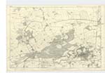
007 | The following description of the Boundary of the Parliamentary Burgh of Elgin is copied from the Reform Act of William 4th. dated 17th. July 1832. From the Bridge on the Fochabers Road over the Tayack Burn, up the Tayack Burn to the Point at which the same would be cut by a straight Line to be drawn thereto due East from Palmer Cross Bridge; thence in a straight Line to Palmer Cross Bridge; thence in a straight Line to the Point at which the River Lossie would be cut by a straight Line to be drawn from Palmer Cross Bridge to Sheriff Mill Bridge; thence down the River Lossie to the Bridge over the same on the Road from Old Mills to Quarry Wood; thence along the Road from Old Mills to Quarry Wood to the Point at which the same joins the Road by Morristown to Lossiemouth; thence down the Road by Morristown to Lossiemouth to the Point at which the same meets ( at the Cross of Bishop Mill), another Road to Lossiemouth; thence in a straight Line to the Bridge first described. The Parliamentary Burgh of Elgin includes part of the parish of Spynie on the north and south of the River Lossie and a part of the parish of St. Andrews Lhanbryd on the east side of the the said river, and in which Newmill Manufactory and Kings Mills are situated. |
Continued entries/extra info
[Page] 2aCounty of Elgin -- Parliamentary Burgh of Elgin
It is superfluous to write this
name on the plans, the name in
Character in page1 being sufficient
Transcribers who have contributed to this page.
Alison James- Moderator, Jeannie Thow
Location information for this page.
Linked mapsheets.